 An official website of the United States government.
 Deepwater Horizon Oil Spill
Incident
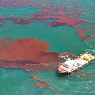
On April 20, 2010, an explosion occurred on the British Petroleum (BP) Deepwater Horizon Macondo oil well drilling platform in the Gulf of America (formerly Gulf of Mexico). The explosion, which tragically killed 11 workers, caused the rig to sink and started a catastrophic oil leak from the well. Before it was capped three months later, approximately 134 million gallons of oil had spilled into the Gulf resulting in the largest offshore oil spill in U.S. history. The incident resulted in an unprecedented impact to the Gulf’s coastal resources and the people who depend on them.
Response
NOAA mobilized within three hours of the explosion to provide expert scientific support for the response; including trajectories of where the oil was going, what resources would be impacted, and weather and oceanographic predictions to the U.S. Coast Guard. Interagency coordination began immediately among federal partners. NOAA, along with the U.S. Coast Guard, the Department of Interior, and the Environmental Protection Agency, as well as other federal, state and local representatives immediately began implementing response plans, providing on-scene and remote technical advice and access to resources and equipment, and overseeing BP’s response. After several unsuccessful attempts to plug the well, a “capping stack” was installed that stopped the release of oil on July 15, 2010.
OR&R Involvement
Science and Coordination
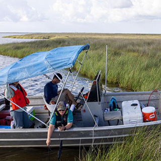
On scene from the earliest moments of the crisis, scientists used data from satellites, aircraft, ships, buoys, and gliders to collect and provide mission-critical information to guide the emergency response to the spill, as well as the long-term assessment and restoration of the Gulf Coast.
Tools in Action
Maps of Shoreline Sensitivity and Coastal Resources at Risk: Responders used Environmental Sensitivity Index (ESI) maps to quickly identify the most sensitive coastal areas at risk from spreading oil, including biological, ecological, historical, cultural, and human-use resources. The color-coded sensitivity rankings on the maps enabled responders to prioritize cleanup efforts and protection strategies in regions with vulnerable wildlife habitats and human-use resources, such as fisheries and recreational beaches. ESI data was instrumental in identifying sensitive habitats and shorelines, and helped damage assessment teams to develop sampling plans.
Oil Spill Trajectory Modeling: The flagship oil spill trajectory model, GNOME, was used by experts to generate daily oil spill trajectories for 107 days of the response. These trajectories estimated where oil from the gushing wellhead would be transported over the next few days. With the possibility of oil being drawn into the northern portion of the Loop Current, experts developed statistical modeling products to examine the probabilities of impacts outside the immediate spill area.
Environmental Response Mapping: Experts incorporated essential environmental response information into NOAA’s web-based geographic information system tool, ERMA®. A month into the spill, the U.S. Coast Guard selected ERMA as the official common operating picture for all federal, state, and local spill responders to use during the incident. With this special designation, ERMA provided a quick visualization of the sprawling, complicated oil spill situation, and improved communication and coordination among responders, environmental stakeholders, and decision makers. Where ERMA integrates both static and real-time data, including ESI maps, ship locations, weather conditions, shoreline oiling conditions, and ocean currents, it provides a real-time overview of response operations and environmental threats.
Data Visualization and Reporting: Within weeks of the spill, NOAA’s damage assessment team created a centralized data management system, now known as DIVER. The data management application centralized and standardized the array of environmental data collected from on-site response and damage assessment efforts, as well as results and analyses from laboratory testing. The DIVER platform became the primary data management and data query tool as the incident’s natural resource damage assessment progressed through 2016. DIVER continues to provide public access to data from the Deepwater Horizon response and damage assessment, and now serves as a nation-wide application that supports OR&R emergency response efforts, NRDA cases, and research projects. DIVER directly supports NOAA’s ability to collaborate and share data and analyses with federal, state, tribal, regional, and local partners.
Damage Assessment and Recovery
Following the spill, OR&R as part of NOAA’s Damage Assessment, Remediation and Restoration Program, and partners conducted a natural resources damage assessment (NRDA) to evaluate the impacts of the spill and specify the type and amount of restoration required. Leading the NRDA process, OR&R provided mission-critical expertise and used field and laboratory studies, scientific literature, and model-based approaches to evaluate potential impacts on fish, wildlife, surrounding habitats, and public use of those resources.
On April 4, 2016, the court approved an $8.8 billion settlement with BP for natural resource injuries caused by the Deepwater Horizon oil spill, concluding the largest natural resource damage assessment ever undertaken. The settlement is funding a multi-year effort to restore fisheries, protected resources, critical habitats (e.g., wetlands, oysters, corals, etc.) and recreational opportunities across the Gulf.
Advances in Science
The Deepwater Horizon oil spill challenged the spill response community, driving advancements in science to better prepare for future incidents. In the decades since the tragedy, OR&R has applied the many lessons learned during the spill to enhance its science, technology, communication, and coordination.
Highlights
- The Deepwater Horizon oil spill emergency launched a fledgling satellite mapping program into action. That program now patrols America’s waterways for accidental or intentional oil spills.
- OR&R scientists have worked to advance the satellite technology — pioneered during the historic spill to detect and map the footprint of floating oil — to now measure its thickness.
- OR&R expanded its oil spill trajectory model GNOME which forecasted where the massive discharge of oil from Deepwater Horizon would go into an integrated suite of oil spill transport and fate modeling tools.
- The toxicity testing program born from assessing Deepwater Horizon impacts created an unprecedented, large, and coherent dataset to draw conclusions about how natural resources in the Gulf of America (formerly Gulf of Mexico) were injured by the disaster. The publicly available body of information expanded the scientific literature available on the ecotoxicity of oil to a wide range of species and continues to facilitate advances in science today.
- Remotely Operated Vehicles examined the impacts of the oil spill on deep-sea corals. A 2014 study determined that observed impacts to life in the deep ocean are closely tied to the Deepwater Horizon oil spill.
- Since 2015, NOAA experts have partnered with scientific leaders specializing in different backgrounds to continue studies to determine how dolphins and large whales were impacted by the spill.
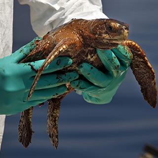
- Marine mammal and sea turtle scientists partnered with oil spill experts to document lessons learned from Deepwater Horizon on the best ways to protect, rescue, assess, and restore sea turtles and marine mammals impacted by oil, resulting in two technical memos.
- NOAA scientists were among the 4,500 researchers involved in the Gulf of Mexico Research Initiative, which resulted in more than 1,700 scientific publications investigating the impacts of oil, dispersed oil, and dispersants on the ecosystems of the Gulf of America following the Deepwater Horizon oil spill.

News and Features
- Restoring Deep Habitats In and Around Flower Garden Banks National Marine Sanctuary
- A Fantastic Journey: From the Seafloor to the Museum Collection
- The Early Days and Hours of Deepwater Horizon
- Attempting to Answer One Question Over and Over Again: Where Will the Oil Go?
- Deepwater Horizon: Response in the Midst of an Historic Crisis
- In Mapping the Fallout from the Deepwater Horizon Oil Spill, Developing One Tool to Bring Unity to the Response
- Effects of the Deepwater Horizon Oil Spill on Coastal Salt Marsh Habitat
- Assessing the Impacts from Deepwater Horizon
- Recalling the Early Hours—and Challenges—of the Deepwater Horizon Oil Spill
- Advances in Science: How Deepwater Horizon Helped Improve NOAA’s Oil Spill Modeling
- 10 Things a Non-Scientist Has Learned in the Decade Since Deepwater Horizon
- From the Deepwater Horizon Incident Command, to the Helm of the Disaster Preparedness Program: A Career Built Around Disaster Coordination
- NOAA’s Eyes in the Sky: How Satellite Technology Pioneered During Deepwater Horizon Patrols America’s Oceans for Pollution
- How Deepwater Horizon Spurred Advances in Oil Toxicity Science
- How Deepwater Horizon Data Tools are Used to Protect America’s Coastal Resources
- Dolphin Discoveries in the Decade Since Deepwater Horizon
- How Many People are on that Beach? NOAA Economists Release Guide to Counting Coastal Recreators
Multimedia
- Timeline: The Deepwater Horizon Oil Spill
- Photo Album: OR&R Photos on Flickr
- Photos from Incident News: Deepwater Horizon aerial imagery accompanying daily situation report updates from OR&R while advising the U.S. Coast Guard.
- Videos: Restoring the Gulf: 10 Years After Deepwater Horizon
- Podcast: Deepwater Horizon Response and Restoration (Making Waves, Episode 57)
- Podcast: Deepwater Horizon, one year later (Making Waves, Episode 73)
- Storymap: Gulf Spill Restoration Projects
- Infographics: Browse OR&R’s library for Deepwater Horizon-related infographics.
Data and Technical Reports
- NOAA Studies Documenting the Impacts of the Deepwater Horizon Oil Spill
- Trajectory Maps: Deepwater Horizon spill trajectories, generated by OR&R from April 21 through August 23, 2010. Trajectory maps predict how an oil spill will spread and move within a local area.
- Deepwater Horizon oceanographic data collected by NOAA National Centers for Environmental Information. The archive provides access to physical, chemical, and biological oceanographic datasets.
- Deepwater Horizon Natural Resource Damage Assessment Data
- Guidelines for Oil Spill Response and Natural Resource Damage Assessment: Sea Turtles
- Guidelines for Assessing Exposure and Impacts of Oil Spills on Marine Mammals
- Best Practices for Collecting Onsite Data to Assess Recreational Use Impacts from an Oil Spill