 An official website of the United States government.
 Since the early 1900s, pulp and paper mills and other industrial facilities discharged effluents into Port Angeles Harbor. These discharges have resulted in harbor sediments contaminated by heavy metals, dioxins, PCBs, and petrochemicals. These finalized settlements will be used to fund projects that restore natural resources injured by hazardous waste pollution. Here, an aerial view of Nippon Mill and Lagoon at the Western Port Angeles Waste Site.
([field_image_credit])Assessment and Restoration
From Superfund sites to oil spills, OR&R is responsible for evaluating and restoring damaged coastal and estuarine habitats. Through NOAA's Damage Assessment, Remediation and Restoration Program, OR&R provides permanent expertise to assess and restore natural resources injured by releases of oil and hazardous substances, as well as by physical impacts, such as ship groundings in National Marine Sanctuaries.


 collects sediment samples while National Park Service scientist inflates the boat near the mouth of the Kitluk River in northwest Alaska")


, 2010 (middle), and 2014 (right).")


 in a fish run in North Kingstown, Rhode Island.")


 closely supervises the collection of an oil sample by Scott Pegau of the Oil Spill Recovery Institute in 2017. This project is to validate and better understand the capabilities of trained oil detection canines to locate subsurface stranded oil. The results of the study may affect the design and implementation of shoreline cleanup and assessment technique surveys for stranded oil.")


")


Western Port Angeles Waste Site

Scientists at Ohmsett test tank facility

Site of Buskin River oil spill incident

Bloede Dam removal and fish passage restoration project

Exxon Valdez: Oil lingering from the spill

Sediment sampling in Alaska
 collects sediment samples while National Park Service scientist inflates the boat near the mouth of the Kitluk River in northwest Alaska")
Practicing sampling techniques in a salt marsh.

Hanford: American white pelicans

Castro Cove restoration plan

Coral restoration
, 2010 (middle), and 2014 (right).")
Cleaning beaches affected by Texas City "Y" oil spill

Federal and local agency workers help clean up the beaches affected by the Texas City "Y" oil spill, which resulted from a collision between a bulk carrier and a barge in the Houston Ship Channel.
([field_image_credit])Anacostia River, hazardous waste site

Recreational kayakers on the Anacostia River, a hazardous waste site, in Washington D.C.
([field_image_credit])Coral nurseries

NOAA uses coral nurseries to help corals recover after traumatic events, such as a ship grounding. Hung on a tree structure, the staghorn coral shown here will have a better chance of surviving and being transplanted back onto a reef.
([field_image_credit])Submerged aquatic vegetation restoration

Submerged aquatic vegetation restoration is an important tool for NOAA to help heal ecosystems injured by pollution. Here eelgrass along the bottom provides foraging areas and shelter for fish.
([field_image_credit])Alewife run
 in a fish run in North Kingstown, Rhode Island.")
Migratory Alewives (Alosa pseudoharengus) in a fish run in North Kingstown, Rhode Island.
([field_image_credit])Hanford Nuclear Reservation

The Hanford site, which the Columbia River passes through, encompasses 586 square miles of sweeping plains alongside an atomic legacy.
([field_image_credit])Lower Duwamish River urban resource

The Duwamish River is truly an urban resource that supports wide-range uses, including: industry, boating, fishing, residential, and just relaxing. Due to industrial and stormwater pollution, the lower 5.5 miles of the river was placed on the EPA's Superfund site list in 2001.
([field_image_credit])Montrose site

Diver removes urchins from an urchin barren to allow for kelp growth as part of NOAA's Montrose Settlements Restoration Program off the coast of California's Palos Verdes Peninsula.
([field_image_credit])Lower Duwamish River barge

The Lower Duwamish River in Seattle remains a heavily used waterway for barges, like this one pictured, and other industrial traffic. Efforts to cleanup and restore the river, for its many different uses, are underway.
([field_image_credit])Richmond Terminal oil spill

Oil sheens at the Richmond Terminal 4 oil spill site in California.
([field_image_credit])Richmond Terminal 4 oil spill - inspecting sediment

NOAA expert inspecting sediment at the Richmond Terminal 4 oil spill site in California.
([field_image_credit])Site of the Richmond Terminal 4 oil spill in California

Site of the Richmond Terminal 4 oil spill in California
([field_image_credit])Coral restoration at the T/V Margara ship grounding site

Coral restoration at the T/V Margara ship grounding site. Here the diver is placing cement around the base of a soft coral that is being reattached.
([field_image_credit])Shoreline Assessment Team studying impacts from the Bouchard Barge 120 oil spill

Shoreline Assessment Team studying impacts from the Bouchard Barge 120 oil spill
([field_image_credit])M/T Athos I, Delaware OIl Spill

The M/T Athos I hit several submerged objects while preparing to dock at a refinery. Oil from the ruptured tanker spread 115 miles downriver, impacting 280 miles of shoreline in Pennsylvania, New Jersey, and Delaware with wide ranging environmental, economic, and recreational impacts. Restoration projects have included oyster reef construction, dam removal and habitat restoration, and improved recreational opportunities.
([field_image_credit])Chalk Point, Maryland Spill

A pipeline ruptured underground at an electric generating facility and spilled into a tributary of the Patuxent River. The spill oiled over 80 acres of wetlands and shoreline, killing more than 1,000 birds and animals and the loss of an estimated 125,000 recreational river trips. Restoration projects bolstered injured habitats and outdoor recreation infrastructure. Pictured here, an oiled muskrat.
([field_image_credit])Chalk Point, Maryland Spill

A pipeline ruptured underground at an electric generating facility and spilled into a tributary of the Patuxent River. The spill oiled over 80 acres of wetlands and shoreline, killing more than 1,000 birds and animals and the loss of an estimated 125,000 recreational river trips. Restoration projects bolstered injured habitats and outdoor recreation infrastructure.
([field_image_credit])Exxon Bayway Oil Spill, New York

567,000 gallons of #2 fuel oil killed over 700 birds, smothered fish, crabs, and clams, and caused massive losses of salt marsh cordgrass. To date, 111 acres of marsh habitat have been enhanced or restored, and more than 80 acres have been acquired for protection. Here, first responders set out oil sorbent pads and boom on Prall's Island in the days following the spill.
([field_image_credit])Exxon Bayway Oil Spill, New York

567,000 gallons of #2 fuel oil killed over 700 birds, smothered fish, crabs, and clams, and caused massive losses of salt marsh cordgrass. To date, 111 acres of marsh habitat have been enhanced or restored, and more than 80 acres have been acquired for protection. Here, Exxon Bayway Volunteers in protective rubber waders work with the New York City Parks and Recreation team to replant cordgrass on the shores of Prall's Island.
([field_image_credit])M/V Everreach, South Carolina

When the M/V Everreach spilled 12,500 gallons of oil into Cooper River it oiled 30 miles of shoreline and impacted a wide range of habitats. To compensate for the pollution 11 acres of salt marsh were restored at a former golf course site, and a project installing a new fishing pier was selected to increase public access to recreational fisheries.
([field_image_credit])M/V Everreach

When the M/V Everreach spilled 12,500 gallons of oil into Cooper River it oiled 30 miles of shoreline and impacted a wide range of habitats. To compensate for the pollution 11 acres of salt marsh were restored at a former golf course site, and a project installing a new fishing pier was selected to increase public access to recreational fisheries.
([field_image_credit])Coast Guard Using ERMA

Members of the U.S. Coast Guard using ERMA, NOAA’s Environmental Response Management Application.
([field_image_credit])Koppers

Koppers Co., Inc. was a wood treatment and fertilizer manufacturing plant that operated from approximately 1940 to 1978. Over time the plant released hazardous substances into the Ashley River, groundwater, and surrounding wetlands. This is the proposed site for hydrologic and habitat restoration on Long Branch Creek in Charleston, South Carolina.
([field_image_credit])Bayou d’Inde

Chemical manufacturing and petroleum refining facilities have released toxins—including PCBs, dioxins, lead, and mercury—into Calcasieu Estuary/Bayou d’Inde in Louisiana and surrounding areas for decades. A 7.9 million settlement was reached for the restoration of fish, birds, and marine mammals.
([field_image_credit])Selendang Ayu oil spill damage assessment

Selendang Ayu oil spill damage assessment
([field_image_credit])Selendan Ayu oil spill

Selendan Ayu oil spill
([field_image_credit])Selendang Ayu oil spill damage assessment

Selendang Ayu oil spill damage assessment
([field_image_credit])Selendang Ayu oil spill damage assessment

Selendang Ayu oil spill damage assessment
([field_image_credit])Sampling Fish after Refugio Oil Spill

Scientists pull in a seine net along a beach near Santa Barbara, California, about a year after the oil spill at Refugio State Beach. They are sampling fish known as surfperch to evaluate any impacts from the oil spill.
([field_image_credit])Commencement Bay Restoration

Beginning in the early 1900s, industrialization in Commencement Bay in Tacoma, Washington, led to the filling of a vast area of tideflats, as well of channelization of the meandering streams and rivers that flowed into the bay. Various industries, including shipbuilding, oil refining, and chemical manufacturing released PCBs, dioxins, and heavy metals into the bay. Since 1990, a significant portion of the contaminated area has been cleaned up by EPA, with NOAA’s technical expertise.
([field_image_credit])Collecting Native Fish for Injury Determination

Scientists seining salt marsh tidal channel collecting native small fish for injury determination in 2016. A seine, lift net, and minnow traps were used to collect fish adjacent to the marsh for species identification and to measure body size and observe possible abnormalities, both external and internal.
([field_image_credit])Using Canines for Oil Detection
 closely supervises the collection of an oil sample by Scott Pegau of the Oil Spill Recovery Institute in 2017. This project is to validate and better understand the capabilities of trained oil detection canines to locate subsurface stranded oil. The results of the study may affect the design and implementation of shoreline cleanup and assessment technique surveys for stranded oil.")
Paul Bunker and Haiden Montgomery assessing the odor of residual Exxon Valdez oil, while Pepper (the dog) closely supervises the collection of an oil sample by Scott Pegau of the Oil Spill Recovery Institute in 2017. This project is to validate and better understand the capabilities of trained oil detection canines to locate subsurface stranded oil. The results of the study may affect the design and implementation of shoreline cleanup and assessment technique surveys for stranded oil.
([field_image_credit])Volunteers Planting Grass at 2010 NOAA Restoration Day Event

Volunteers plant Switch Grass during the 2010 NOAA Restoration Day event at the NOAA Cooperative Oxford Lab in Oxford, Maryland.
([field_image_credit])Restoring Habitat Post-Deepwater Horizon Oil Spill

Beach habitat was part of the 2016 Deepwater Horizon oil spill settlement.
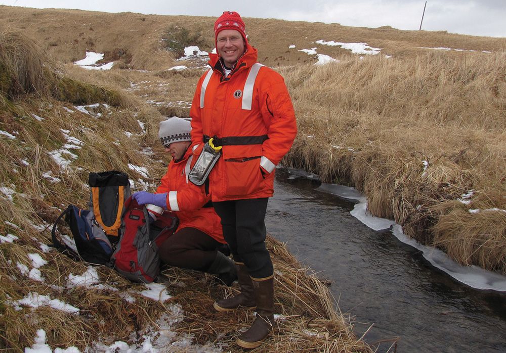
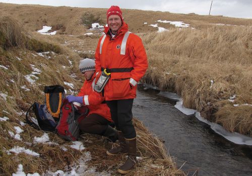
([field_image_credit])Collecting Baseline Sediment Samples in the Arctic

OR&R scientist Sarah Allan collecting baseline sediment samples at the Kitluk River in Alaska.
([field_image_credit])Kayaking on the Kalamazoo River

Paper mills conducting carbonless copy paper recycling released PCBs into the Kalamazoo River from the late 1950s through the early 1970s. EPA’s cleanup efforts are ongoing.
([field_image_credit])Pierce Marsh, Texas

A small levee constructed in Pierce Marsh, near Galveston Bay, Texas, in 2016 contains dredged sediments that will restore marsh elevation and improve habitat quality. Image credit: NOAA
([field_image_credit])Restored Tidal Marsh in New Jersey
")
From landfill to vibrant tidal marsh, the wetland restoration at Lincoln Park in Jersey City, New Jersey, was made possible with funding from multiple oil spill settlements and the American Recovery and Reinvestment Act.
This project restored a significant area of coastal wetlands in New York-New Jersey harbor's Arthur Kill ecosystem. ([field_image_credit])
Hudson River tributary

Starting in 1947 and for approximately 30 years, manufacturing plants operated by General Electric Company (GE) discharged PCBs into the upper Hudson River, with additional releases of PCBs occurring as well. ([field_image_credit])
Aquatic restoration projects on the Housatonic River in Connecticut

The latest round of aquatic restoration projects for the Housatonic River will also indirectly improve water quality, increase buffering during coastal storms, and reduce runoff pollution into the river. ([field_image_credit])
Industrial pollution in the Duwamish River

As a result of industrial activities along the Duwamish River in Seattle, Washington, NOAA is evaluating possible injuries to the benthic community including flatfish and salmon. ([field_image_credit])
Alcoa Aluminum plant

For decades, two Alcoa alumininum facilities discharged toxic PCBs into the St. Lawrence River, its tributaries the Grasse and Raquette Rivers, and the surrounding area in Massena, N.Y. Alcoa and Reynolds are paying $19.4 million to settle the resulting damages to natural resources. ([field_image_credit])
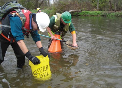
Two people sampling in a stream after the Adak oil spill

In the wake of the 2010 oil spill on Adak Island, a field team member from the Alaska Department of Fish and Game breaks the ice to prepare a stream for sampling, in this case, for electrofishing. Field teams also were setting small fish traps, which do not require breaking up the ice like this.
([field_image_credit])Scientists Sampling Sediments at Federal Creosote Superfund Site in New Jersey

Scientists gather sediment samples along the Millstone River to assess the extent of contamination from the Federal Creosote Superfund Site in Manville, N.J. (NOAA)
([field_image_credit])Sampling Fiddler Crabs in Puerto Rico

Scientists collect fiddler crabs on Vieques Island, Puerto Rico, in 2008 as part of a study conducted by NOAA to characterize chemical concentrations of hazardous substances in both land and fiddler crabs. (NOAA)
([field_image_credit])Water Celery in the Hudson River

Water celery is the dominant aquatic vegetation in the Upper Hudson River (N.Y.) and serves as important foraging, nursery, and sheltering habitat for a variety of invertebrates, fish, and wildlife. The vegetation here was photographed in 2004. (NOAA)
([field_image_credit])Emergent Wetland Plants

Emergent wetland plants, such as great burreed, pickerelweed and white pond lily, grow along the Griffin Island Causeway (N.Y.) in 2004. These plants comprise the fringing riverine wetlands of the upper freshwater Hudson River, which includes the backwater area behind Griffin Island. (NOAA)
([field_image_credit])Assessing Impacts to Mussels from Response-related Boat Traffic
Following an oil spill on the Kalamazoo River in Michigan in 2010, scientists assessed impacts to mussel shells from response-related boat traffic. (NOAA)
([field_image_credit])Assessing Damage After a Diesel Fuel Spill in Alaska
Scientists assess damage to the environment after a diesel fuel spill in the Aleutian Islands in 2010. (NOAA) ([field_image_credit])
Restored Wetland in Texas

Hazardous substances released over time from a Gulf of Mexico oil refinery required NOAA and its partners to restore intertidal marsh at the Lower Neches Water Management Area in Port Arthur, Texas. Photographed here in 2006. (NOAA)
([field_image_credit])McLane Dam at the Fletcher Superfund Site

Downstream view over the McLane Dam at the Fletcher Superfund Site in Milford, N.H. Here, water was being drawn down behind the McLane Dam in order to take samples from the Souhegan River. River sediment data will help determine the movement of polychlorinated biphenyls (PCBs) downstream from the waste site (a former paint manufacturing facility) and the feasibility of dam removal. (NOAA)
([field_image_credit])Public Meeting for Deepwater Horizon/BP Stakeholders

As part of the Deepwater Horizon/BP oil spill restoration process, a public meeting is held in March 2011 in Houma, La. (NOAA)
([field_image_credit])Sampling Sediments After PEPCO Pipeline Leak

After the 2000 pipeline leak of oil from the Chalk Point PEPCO facility into Swanson Creek in Maryland, a scientist samples sediment to determine the impact on bottom-dwelling creatures. (NOAA)
([field_image_credit])Assessing Marsh Damage in Louisiana

Standing on an oiled marsh island in Louisiana, BP consultants discuss field observations with NOAA's Natural Resources Damage Assessment team while checking for oil from the Deepwater Horizon/BP well blowout in the marsh island's sediment. (NOAA)
([field_image_credit])