Pollution Response in the Wake of Hurricane Ian
DEC. 19, 2022 — After plowing a path of destruction through the Caribbean, Hurricane Ian struck Florida on Sept. 28 and moved up the East Coast, with damaging winds, severe flooding, and life-threatening storm surge.
NOAA collected and identified damage assessment images in specific areas, in coordination with the Federal Emergency Management Agency and other state and federal partners. Collected images are available to view online via the National Geodetic Survey aerial imagery viewer. (View tips on how to use the imagery viewer.)
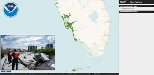
In Ian’s aftermath, NOAA collected aerial imagery of areas across Florida and South Carolina from Sept. 29 to Oct. 3. Two aircraft flew over more than 16,322 square kilometers during 54.6 hours and collected 13,172 images that were used to identify over 6,200 potential pollution risks, such as oil or other hazardous materials from vessels and containers blown ashore.
This same imagery is uploaded into tools such as ERMA® (Environmental Response Management Application) to display and help coordinate the U.S. Coast Guard and the state’s assessment and removal of displaced vessels, containers, and other debris from waterways and upland properties. ERMA also allows NOAA to share data with federal partners such as FEMA and the U.S. Coast Guard, as well as state, county, and tribal partners.
NOAA has also been training assessment teams from the U.S. Coast Guard and Florida Fish and Wildlife Conservation Commission in how to use an app to identify, document and help remove vessels—allowing the assessment teams to contact owners and insurance companies and reunite vessel owners with their property.
NOAA and partners have further used these images to identify other pollution risks, such as oil or other hazardous materials from vessels and containers blown ashore. The team completed a monumental task in record time—assessing an area of approximately 2,215 square miles in three counties, and identifying over 7,000 potential sources of pollution.
The collection and analysis of these images greatly assists affected regions by helping reunite owners with their boats, facilitating the removal of derelict vessels and debris from waterways, assisting the Coast Guard in clearing potential pollution sources from the environment, and supporting safe navigation.
For more information please visit NOAA’s Office of Response and Restoration website.
 An official website of the United States government.

