Pacific Islands ERMA

Visit Pacific Islands ERMA to visualize data and explore the region.
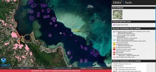
The U.S Pacific Islands region emcompasess the Hawaiian Islands and outlying territories, including Guam, Saipan, American Samoa and Johnston Atoll. It’s an incredibly diverse region, home to extensive coral reefs, endangered marine mammals like the Hawiian monk seal, along with deep-water reefs, hydrothermal vent communities, and rare marine archaeological resources. Unfortunately, the Pacific Islands also face challenges from natural disasters like tsunamis and hurricanes, and man-made challenges like marine debris, oil spills, and ship groundings. Pacific Islands ERMA is an online mapping tool which integrates key environmental data to help experts use sound science to make decisions that protect people, property, and the environment in this diverse region.
Emergency Response
- The U.S. Coast Guard Sector Guam uses ERMA’s data and tools to develop Geographic Response Plans (GRP) for Guam and the Northern Mariana Islands. The nautical charts, Environmental Sensitivity Index maps, coral habitats, and satellite imagery available in ERMA are instrumental in planning oil spill booming strategies and designating priority areas for protection in the event of an oil spill in active port areas.
- Local experts use ERMA’s “draw tool” to map environmentally sensitive species and habitats, which are reviewed by other federal and state partners and verified in the field, to integrate local knowledge into Area Contingency Plans.

Restoration
NOAA uses Pacific ERMA to assess natural resources at risk from pollution, plan for and track injury assessment, and determine appropriate restoration in the event of a ship grounding, oil spill, or chemical spill.
more images

 An official website of the United States government.
