OR&R Economists Present on Using Remote Sensing to Study Impacts of Pollution on Outdoor Recreation at Public Parks
JUNE 14, 2021 ─ The Association of Environmental and Resource Economists (AERE) Summer Conference was held virtually between June 2 and 4 and attracted more than 600 registrants around the world. This year, OR&R’s Assessment and Restoration Division (ARD) sponsored a session on the use of new data sources, which attracted more than 80 participants. Cameron Duff presented ARD’s novel method for estimating lost recreation due to disasters like oil and chemical spills.
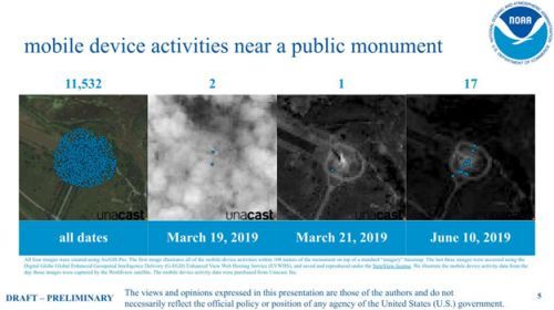
This exciting research explores the use of mobile device location data and satellite imagery to quantify recreation at public parks. The ability to collect on-site data remotely has been invaluable throughout the challenges of 2020-2021 and their impacts on travel. The method exploits already existing, and continuously collected, data.
The ability to retrieve data after-the-fact of an incident is an important benefit because it is impossible to predict environmental disasters in advance; human-use data are really no longer ephemeral in the traditional sense. Because not everyone has mobile devices and shares location data with their applications, the OR&R economists must estimate the coverage rate. Counts, developed from machine learning algorithms counting automobiles in the parking lots of parks from satellite imagery, are used to calibrate the mobile device data. Estimates of lost park trips and the value of recreation trips are developed using econometric techniques.
The economists are excited about the possibilities of remote sensing for valuing recreation. In particular, they hope the cost-effectiveness, relative to traditional data collection methods, will help ARD and DARRP make the public whole following anthropogenic environmental disasters.
For more information contact Cameron.Duff@noaa.gov, Jason.Murray@noaa.gov, or Christopher.Giguere@noaa.gov.
 An official website of the United States government.


