Map of the Month: Sediment and Tissue Sampling in the Pacific Northwest
The Environmental Response Management Application (ERMA®) is NOAA’s online mapping tool that integrates both static and real-time data, enabling users to quickly and access, analyze, and display spatial data for environmental decisions. The "Map of the Month" series highlights unique maps from throughout ERMA's use and history.
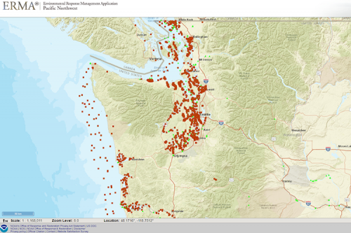
This is a map showing environmental sediment and tissue chemistry data sampling locations throughout the Pacific Northwest where sediment, water, and tissue from fish or other freshwater organisms were collected and analyzed in a laboratory for specific contaminants.
These data come from 355 separate studies conducted by federal, state, local and nongovernmental organizations and represent sampling done over 48 years at 11,748 stations.
As part of NOAA’s responsibilities as a natural resource trustee, our team uses these data (sometimes collecting data ourselves) to inform our natural resource damage assessments and restoration efforts in places such as the Lower Duwamish River, Portland Harbor, and Commencement Bay.
All of these studies have been gathered, standardized, and made publicly available through the DIVER application, a NOAA-developed data warehouse and query tool. NOAA and our partners also use these data in our Environmental Response Management Application (ERMA) for planning and response to oil and other hazards spilled into the environment.
Click here to view the data in ERMA.
View the filtered data query in the Public DIVER Explorer application here.
February’s "Map of the Month" comes from the Spatial Data Branch’s Ben Shorr and Nicolas Eckhardt in sunny Seattle.
 An official website of the United States government.
