In the Aftermath of Hurricane Sally
OCTOBER 13, 2020 — Hurricane Sally made landfall at Gulf Shores, Alabama, on September 16, 2020 as a Category 2 storm with sustained winds of 105 mph and devastating storm surge. Battering the Alabama and Florida coastlines for over six hours, the storm’s impacts extended across a broad area of the northern Gulf of Mexico.
As with Hurricane Laura, National Environmental Satellite, Data, and Information Service (NESDIS) provided satellite surveillance of the offshore oil and gas production areas at risk from Hurricane Sally. The storm’s eastward trajectory largely spared these areas, but the impacts to the coastal communities were significant. The hardest hit areas were from Gulf Shores, Alabama, east to the Florida Panhandle. Close to 1,000 pollution targets, mostly sunken and stranded commercial and recreational vessels, have been identified to date.
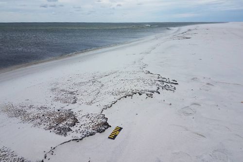
The storm's impacts also included a half-mile stretch of oiling along the Gulf Islands National Seashore on Perdido Key, Florida.
OR&R teams are working with the state and federal resource agencies and the U.S. Coast Guard to survey the affected seashore and to help track and assess the vessel targets. The OR&R team is also helping develop Best Management Practices for vessel removal and salvage to avoid and minimize response disturbance to sensitive habitats and historic properties during the cleanup operations.
For further information, contact Doug.Helton@noaa.gov, or Donna.L.Roberts@noaa.gov.
 An official website of the United States government.

