Fiscal Year 2022: Assessing and Restoring our Nation's Shores After Pollution
The Office of Response and Restoration's Assessment and Restoration Division (ARD) is responsible for evaluating and restoring coastal and estuarine habitats damaged by hazardous waste releases, oil spills, and vessel groundings.
Working with partners, ARD, through NOAA's Damage Assessment, Remediation, and Restoration Program, which includes the Restoration Center and General Counsel for Natural Resources, determines the harm to the environment and defines the amount of restoration required to compensate the American public for those impacts.
$114 Million Recovered from Pollution Settlements for Restoration in Five States
This year NOAA’s Office of Response and Restoration and our partners recovered $114 million through pollution settlements for restoration. These settlements include three oil spills and three hazardous waste (Superfund) settlements, often in communities disproportionately affected by pollution.
- $73.5 million to build a riverside park in East Newark, New Jersey to create a safe green space for underserved urban communities disproportionately impacted by industrial pollution.
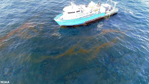
- $16.5 million to restore the Gulf of Mexico from the Taylor Energy oil spill—the longest offshore oil spill in United States history.
- $15.3 million to restore coastal habitats and marine mammals in Texas after an oil spill in the Port of Houston.
- $5.3 million to restore fisheries and marsh in Louisiana after an oil spill near New Orleans.
- $2.5 million to remove invasive mangroves in Pearl Harbor in Oahu, Hawaii after industrial pollution.
- $0.5 million to restore an urban waterway in Pennsylvania for oysters, migratory fish, and birds.
These actions add to over 30 years of pollution settlements recovering $10.5 billion for restoration across the country. This work is undertaken through NOAA’s Damage Assessment, Remediation, and Restoration Program and conducted in partnership with federal, state and tribal partners.
Studying Superfund Sites Across the Nation
 Years-long studies at Superfund, or hazardous waste pollution, sites are critical to holding polluters accountable for settlements that fund restoration. This year, NOAA experts and our partners successfully conducted important studies of four sites.
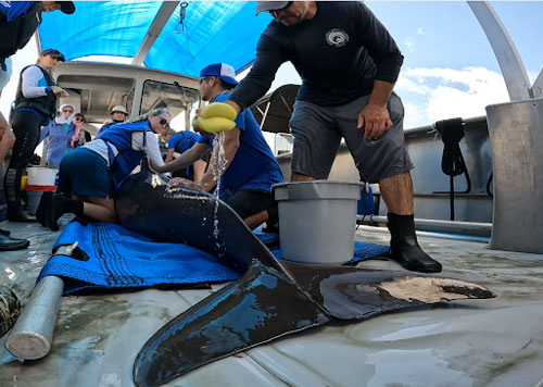
In coastal Georgia, more than 30 marine mammal experts, including multiple NOAA offices and our partners, spent two weeks conducting health assessments on bottlenose dolphin populations exposed to hazardous waste pollution. The samples and health assessments collected provide a wealth of information about how pollution could be impacting marine mammals.
At an urban river in New Jersey, NOAA scientists and partners examined how polluted sediment impacts fish. Using two fish species, white perch and mummichog, scientists studied how pollution impairs fish reproduction, development, and survival. They also engaged local historically underserved communities to foster transparency and listen to their concerns.
In the Pacific Northwest teams battled record heat to study two urban rivers in major cities. NOAA scientists and partners collected fish samples, including protected salmon species, to examine the relationship between contaminant concentrations in whole bodies and fish growth.
These studies were supported in the field with a robust data collection system and staff that ensured the data were collected in a legally defensible manner for these highly important scientific and legal pollution cases.
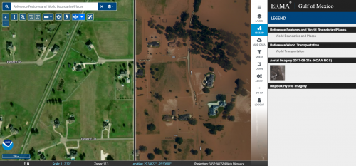
Technological Updates for NOAA’s Environmental Response Management Application
The Environmental Response Management Application (ERMA®) is an online mapping tool that integrates both static and real-time data such as oil spill footprints, weather, and ocean currents, in a centralized, easy-to-use format for environmental and emergency responders.
This year NOAA’s Office of Response and Restoration released new technological updates to ERMA. The updated version features an overhauled look and layout—providing a streamlined interface to visualize and explore spatial data. New features include compatibility with mobile devices, consolidated search functions, and a new swipe map tool to enable side-by-side, before and after comparisons.
ERMA is the common operational picture for NOAA and the U.S. Coast Guard during environmental responses like oil spills. It provides centralized access for environmental resource managers with the data necessary to make informed decisions during a response, damage assessment, recovery, and restoration. NOAA used input from our users to inform ERMA’s updates and new design.